Satellite imaging is prevalent in many consumer applications today, such as Google Earth, Google Maps, Microsoft’s Bing maps and many in car GPS systems. Nearly everyone has seen a satellite image of their town, their favorite college football team’s stadium or even their own home. I have one of Penn State’s Beaver Stadium in my den. It should come as no surprise then, when one thinks of using satellite imaging in the study of agriculture crops that it is these familiar images that come to mind. Images of corn fields and soybean fields with a farmhouse or barn nearby. Many are surprised to learn that the practice of using satellite imaging in agriculture truly is much more science than art.
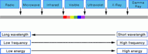
Visible light occupies a very small frequency band of the electromagnetic radiation spectrum, which ranges from long wavelength, low energy radio waves to short wavelength, high energy Gamma Rays. Satellite sensors are able to capture reflected light radiation in both the visible range, as demonstrated by the pictures we frequently see, and the non-visible range, which is the most valuable in the study of agriculture. By measuring the reflection and absorption of various frequencies within the electromagnetic radiation spectrum, scientists are able to extract and analyze spectral signatures that allow for the identification of specific vegetation types as well as the measurement of key plant characteristics such as chlorophyll and water content. This information taken over regular intervals allows for monitoring crops through an entire growing season and when combined with complex models and historical data, it provides an accurate prediction methodology for crop yields, crop area and crop production.
Check back often to further explore the current and potential future impact that satellite imaging will have in the agriculture industry. Share your experience and expertise through the comments section and follow us on Twitter, LinkedIn, Facebook or through the available RSS feed.


 Follow
Please keep trwhoing these posts up they help tons.
Stellar work there eveyorne. I’ll keep on reading.