An Opportunity to Join the CropSignal User Feedback Group

CropSignal Launches User Feedback Group

Rewards Participants with Free Subscriptions

Want to know what new features are coming to CropSignal? Interested in weighing in with your opinion and expertise? Want to influence how new features work and what new content is made available?

Request to join our User Feedback group and use CropSignal for free through 2011.

After our successful launch of CropSignal, it is time for the CropSignal team to get back to work on enhancing the user experience, developing new features, adding new content and moving closer to our goal of redefining the agriculture intelligence industry.

As a member of the CropSignal User Feedback group we will share with you what we are working on and ask for your thoughts and opinions. We may ask you specific questions, show you screenshots or add functionality to your user account for you to try.   It is important for us to hear from you and know what your thoughts and needs are.

This CropSignal User Feedback group is for current or new users who intend to actively participate and be available to answer questions, test new features and provide feedback in a timely fashion. We understand that your time is valuable—to this end, we are pleased to offer User Feedback group members a free subscription to CropSignal for the remainder of 2011. Please note that the group will have a limited membership and you must request to join the group by taking a brief survey. If you are a current user and are selected for the group your subscription will be changed to free and follow the standard terms and conditions for subscription changes.

If you are interested in helping us define the future of CropSignal, you can request to join the CropSignal User Feedback group at www.surveymonkey.com/s/CropSignal_UserGroup

Thanks in advance and we look forward to your feedback!

Sincerely,

The CropSignal Team

www.CropSignal.com

Posted in Uncategorized | 3 Comments

CropSignal is Available Now

GDA Corporation Introduces CropSignalTM; Redefines Agricultural Intelligence Market

CropSignal redefines Agricultural Intelligence delivery and analysis capabilities with a cloud based on-demand database management, analysis and visualization platform

June 28th, 2011 – Geospatial Data Analysis Corporation (GDA), a leader in satellite-based agricultural and environmental intelligence gathering and distribution, announced today the introduction of CropSignal, www.CropSignal.com. CropSignal is an Agricultural Intelligence on-demand platform that empowers users with unprecedented access to the latest in public sources of agricultural intelligence data, ranging from crop statistics to weather to supply and demand, as well as a range of analytical and visualization tools to make the most of the vast stores of data.

Commodity trading, farm operations, logistics planning, resource management and agriculture enterprise companies are always looking for an edge, relating to the latest agricultural intelligence available, to assist them in making complex decisions every day. The only solutions available to date are public sources that lack the timeliness and ease of use required and private sources that are high cost and allow little to no analysis or custom visualization capabilities.

CropSignal changes the dynamic of the market place by offering the ultimate in user flexibility in the manipulation, analysis and report generation of intelligence data, all in a cost effective on-demand platform. User subscriptions start as low as $79 per user per month and CropSignal is available to any user with an internet connection and a browser. No software downloads are required allowing for true 24/7 access anywhere in the world.

“We have a great deal of experience in agricultural intelligence data and the operational delivery of that intelligence to several US government agencies,” said Stephanie Hulina, CEO of GDA Corporation. “We felt what was available in the private sector lacked the flexibility and tools required to truly allow people to couple their expertise with the available information. We believe providing this will create real and quantifiable advancement in the use and value of agricultural intelligence.”

CropSignal combines data from multiple public sources, including various agencies within the USDA. Enterprise customers, through the customizable Enterprise subscription level, have additional data capabilities such as importing their own datasets as well as accessing GDA’s satellite image-based proprietary crop intelligence services.

With CropSignal, users can simply monitor a catalog of standard reports and executive dashboards (whose results are continuously refreshed when new data is available) or dive into a full blown analysis by accessing the raw data and a simple to use library of analysis and visualization tools, including interactive charts and maps.  Providing users with data collection and database management services along with a full range of analysis capabilities demonstrates one of the true powers of CropSignal.

Availability

CropSignal is available today by visiting http://www.CropSignal.com

About GDA Corporation

Geospatial Data Analysis Corporation (GDA) is a recognized leader in agricultural intelligence and a leading solutions provider to the USDA and other federal and state government agencies. GDA specializes in the analysis of satellite imagery and, in particular, the automated pre-processing, data extraction, analysis and operational delivery of intelligence products for the agricultural, environmental and resource management arenas. GDA is built on the principle that the use of advanced science and technology can have a profound impact on the world in which we live.

To learn more about GDA please visit our corporate website at www.gdacorp.com.

Posted in Uncategorized | Leave a comment

Product Tour Presentation for CropSignal

Posted in Uncategorized | 1 Comment

Overview Presentation for CropSignal

Posted in Uncategorized | 2 Comments

What’s Missing in Today’s Agricultural Intelligence Solutions?

Last week I published a blog with a quick overview of today’s Agricultural Intelligence Market. After thinking about this more, I realized that the key missing ingredient in today’s solutions is the user or purchaser of agricultural intelligence. So what do I mean by that?

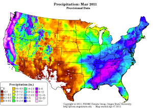
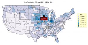
Precipitation Map for the USA. How do you use this for gaining insight? How many acres are effected by heavy precipitation? By no Precipitation?

When you think of the different ways of gaining agricultural intelligence, whether it is free data from the USDA or purchased data from a private company, what you get is a ream of data. This may be in the format of an excel spreadsheet, as the USDA is moving towards today, or it may be in the form of a PDF report that contains tables, charts and possibly maps, such as the one shown here, that provide visual views of the data. Whatever the case, the one thing that none of these solutions allow you to do is actually interact with the data. Why is this important?

Each of us brings a particular level of experience and area of expertise. To bring the greatest value to our company, firm or just our individual trading needs, we need to be able to utilize our expertise to its fullest potential and from an agricultural intelligence perspective that means rolling up our sleeves and diving into the data instead of just looking at static presentations of it. With enough time, resources and database skills, we can likely, eventually, create an interactive database to allow us to truly “investigate” the information we are given but I am certainly not one who has that luxury and I doubt very many of us do. This is a major drawback with today’s solutions.

Regardless of your need for agricultural or crop intelligence there are likely specific crops, locations or time periods that you would like to focus on. There are likely specific bits of data that are important to you. Maybe all you care about are production numbers at the country level. That would be easy to gain from almost any solution. But what if you need more? What if you want to focus on a specific state or region, a specific crop, you care about production but you also care about crop progress, crop health, yield and weather? What if you want to relate different data sets to each other? How do today’s solutions help you bring all this information together?

In fact they don’t. Not at all. In the end you are left with lots of data and no real way to inject your expertise and skills to bring real value to the information you downloaded or purchased.

Perhaps it is time to ask for more from Agricultural Intelligence providers. It is time to allow you to utilize your greatest asset. You!

Posted in Uncategorized | 2 Comments

Satellite Imaging in Agriculture : More than Meets the Eye

Satellite imaging is prevalent in many consumer applications today, such as Google Earth, Google Maps, Microsoft’s Bing maps and many in car GPS systems. Nearly everyone has seen a satellite image of their town, their favorite college football team’s stadium or even their own home. I have one of Penn State’s Beaver Stadium in my den. It should come as no surprise then, when one thinks of using satellite imaging in the study of agriculture crops that it is these familiar images that come to mind. Images of corn fields and soybean fields with a farmhouse or barn nearby. Many are surprised to learn that the practice of using satellite imaging in agriculture truly is much more science than art.

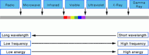
Infrared, Visible and Ultraviolet can all play a role in agriculture and enviromental analysis.

Visible light occupies a very small frequency band of the electromagnetic radiation spectrum, which ranges from long wavelength, low energy radio waves to short wavelength, high energy Gamma Rays. Satellite sensors are able to capture reflected light radiation in both the visible range, as demonstrated by the pictures we frequently see, and the non-visible range, which is the most valuable in the study of agriculture. By measuring the reflection and absorption of various frequencies within the electromagnetic radiation spectrum, scientists are able to extract and analyze spectral signatures that allow for the identification of specific vegetation types as well as the measurement of key plant characteristics such as chlorophyll and water content. This information taken over regular intervals allows for monitoring crops through an entire growing season and when combined with complex models and historical data, it provides an accurate prediction methodology for crop yields, crop area and crop production.

Check back often to further explore the current and potential future impact that satellite imaging will have in the agriculture industry. Share your experience and expertise through the comments section and follow us on Twitter, LinkedIn, Facebook or through the available RSS feed.

Posted in Uncategorized | 2 Comments

How Satellite Imagery Changes the Way We Think About Agricultural Intelligence

In our last blog we discussed three broad categories of agricultural intelligence solutions available today. The third category included the use of satellite imagery, which by all accounts, has the ability to forever change our view, expectations and usage of agricultural intelligence.

The promise of satellite imagery is tied to the fact that every point on earth can be captured in a satellite image up to four times a day. While the resolution of the satellites that make such frequent passes may not provide high resolution pictures for Google Earth, they do contain highly useful information on crops. Compare this to the current way data is obtained for information such as crop acreage, yield projections, production estimates and crop conditions. Today these are still very manual processes and an inexact science.

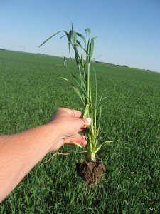
While important, manual crop sampling can not possibly provide 100% coverage of crops like satellite imagery can.

Data collected by the USDA, large agriculture corporations and farm owners alike are still based on phone surveys, crop tours surveying a few square feet area to extrapolate yield for thousands of acres. When used in conjunction with large historical databases this provides serviceable information but nothing compared to what is achievable today or the future promise of what will be achievable through the use of satellite imagery.

Today a few companies, such as GDA, provide agricultural intelligence based on satellite imagery. While we have made tremendous progress over the past decade in optimizing our technology and developing operational delivery of agricultural intelligence, we are just scratching the surface of what is possible. With the introduction of higher resolution satellites, advances in cloud computing and continued development of our own technologies, the full promise of remote sensing and satellite imagery is right around the corner.  It’s going to be a fun ride!

Do you foresee using satellite image based agricultural intelligence? Why or why not?

Share your experience and expertise through the comments section and follow us on Twitter, LinkedIn, Facebook or through the available RSS feed.

Posted in Uncategorized | 5 Comments

Quick Overview of Today’s Agricultural Intelligence Market

Agricultural intelligence in today’s market can broadly be divided into three categories:

1)      Publicly available free data

2)      Analysis provided by consulting/analyst firms

3)      Proprietary data provided by agricultural intelligence companies

The largest and most important provider of agricultural intelligence falls into category 1 where the USDA is the leading provider and, in many ways, drives the overall industry and financial markets. Also in this category, are a number of university and research websites where local, regional or area of study information can be accessed.

Categories 2 and 3 are a mix of small, medium and a handful of large corporations that provide solutions ranging from analysis of publicly available information to information based on their own manual collection and sampling data to highly proprietary data based on satellite/airborne imagery, and/or mathematical models.

Each category has their advantages and disadvantages as shown below:

Category Advantage Disadvantage
Publicly available free data It’s free, well respected sources, broad range of raw data available Hidden costs in gathering data, getting into usable format, combining multiple sources, database development and management
Analysis from consulting/analyst  firms Time savings, utilize industry expertise and experience, ability to utilize firm(s) with specific crop, commodity or regional expertise High cost, limited differentiation from other customers using the same analysis, finding a firm you trust, little to no ability to get customized analysis without significant cost increases
Proprietary Data Availability of newer technologies and promise of providing greater accuracy and much improved timeliness Very high cost, limited differentiation from other customers using the same analysis, customized analysis not available or cost prohibitive to most.

Do you use one of the solutions above? Do you agree with the advantages/disadvantages? Any you would add? What are your thoughts of solutions available today?

Share your experience and expertise through the comments section and follow us on Twitter, LinkedIn, Facebook or through the available RSS feed.

Posted in Uncategorized | Leave a comment

What is Agricultural Intelligence?

As we kick off our CropSignal blog, we thought it would be a good idea to dive into the term agricultural intelligence. While we constantly use the term internally, we realize that the different markets use similar terms such as agribusiness intelligence, crop intelligence or other terms to describe what we consider agricultural intelligence. So a quick definition of what we consider agricultural intelligence is in order before we jump into further discussions.

Maps, such as the precipitation map above, play an important role in agricultural intelligence.

At GDA we use the term agricultural intelligence to broadly refer to  any data or information that has an impact on the agriculture industry. Agricultural intelligence includes typical crop related data such as statistics for yield, acreage, production, crop progress, crop condition and crop health. Agricultural intelligence also includes ancillary data such as weather, including precipitation, temperature and growing degree days and financial or market information such as supply and demand, crop prices, futures prices, imports, exports etc. Additionally, agricultural intelligence should include changes in government policies and laws, key business changes by market leaders and more. As you can see we believe in a very broad definition for agricultural intelligence. While we will intend to provide a heavier focus on crop related information, where our technology provides unique insight, we intend on touching on all these areas in the CropSignal blog and keeping our readers informed on the industry as a whole.

We encourage you to bring new ideas, request specific topics, bring your expertise through the comments section and follow us on Twitter, LinkedIn, Facebook or through the available RSS feed.

Posted in Uncategorized | Leave a comment

Welcome to CropSignal

Our New CropSignal Logo, look for it when you are looking for a trusted source of agricultural intelligence!

CropSignal is a blog focusing on global agribusiness issues, agricultural intelligence and crop intelligence. CropSignal is brought to you by Geospatial Data Analysis Corporation, www.gdacorp.com, an industry leader in Remote Sensing applications and the utilization of satellite image data extraction and analysis in the areas of agriculture and the environment. We have a long history of working with key government agencies including the U.S. Department of Agriculture (USDA), U.S. Environmental Protection Agency (EPA), U.S. Geological Survey (USGS), DOD’s National Geospatial-Intelligence Agency (NGA), National Aeronautics and Space Administration (NASA) and others.

After over a decade of developing and refining our technologies through research and partnership with the above Federal agencies, we began offering our technology to the public sector on an increasing basis over the past five years. For 2011, we have big plans to provide new capabilities and value to new markets such as commodity trading, farm management, logistics and resource planning and more. The CropSignal blog will focus solely on the agriculture industry through insight into current agriculture issues, introduction of new technologies and providing unique insight into the current growing season. Our blog is our first step in reaching out and bringing value to a new audience.  We hope you join us and participate with us as we maneuver through the 2011 growing season.

We encourage you to bring new ideas, request specific topics, bring your expertise through the comments section and follow us on Twitter, LinkedIn, Facebook or through the available RSS feed.

Posted in Uncategorized | 1 Comment